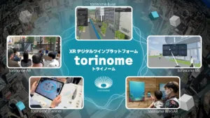
HoloLab Inc. participated in the construction of a digital infrastructure for urban spatial information implemented by Fujisawa City, Kanagawa Prefecture, providing utilization support and technical cooperation using its proprietary XR digital twin platform, “torinome.” HoloLab participated as a cooperating company of Aero Toyota Co., Ltd., the maintenance provider.

Fujisawa City is participating in the Ministry of Land, Infrastructure, Transport and Tourism’s Project PLATEAU, aiming for the cross-disciplinary use of 3D city models. However, there has been a challenge in that its use tends to be limited to specialized applications, making it difficult to expand into other fields. HoloLab addressed this challenge with “torinome,” which allows users to intuitively handle 3D data using a web browser or AR without requiring specialized knowledge such as GIS.

Scenes from an internal study session / PLATEAU Use Case uc23-02: Precise landslide simulation
Within the city hall, during a study session for Fujisawa City employees, the output data for nine PLATEAU use cases was displayed on “torinome Base,” a 3D map operable via a web browser. This provided participants with an opportunity to actually operate and experience the system. The use of PLATEAU was considered for themes relevant to the practical work of each department, such as infrastructure management and citizen dialogue.

Workshop experience: Overlaying a 3D city model (buildings) with tsunami inundation predictions and designated emergency evacuation sites/locations (open data).
At a council meeting attended by practical staff from neighboring municipalities, methods for developing 3D city models and examples of their use were introduced. In the hands-on session, open data such as tsunami inundation predictions, fire spread simulations, and evacuation center location information were overlaid and visualized on “torinome.” Participants were able to concretely experience the use of disaster prevention, such as checking how many floors a building would be flooded and recreating how a fire spreads over time.

Scenes from the digital twin experience event / 3D city model and Fujikyun♡ / 3D city model converted to Minecraft data
On March 23, 2026, a symposium and a “Digital Twin Experience Event” were held, hosted by Fujisawa City. At the event, 3D city models of the areas around Fujisawa Station and Enoshima/Katase-Enoshima Station were displayed on a table using augmented reality (AR). Data converted to Minecraft format and the city’s character “Fuji-Kyun♡” were also displayed, providing an intuitive experience for both children and adults to interact with the data.
“torinome” is a platform that visualizes 3D city models, GIS data, and 3D models on 3D maps and integrates with multi-device compatible XR applications. HoloLab plans to continue supporting its use in a variety of scenarios, including within government offices, at public briefings, and in educational settings.
“torinome” Overview
| Implementation period | Reiwa 7th year (2025) |
| Date of the trial session | March 23, 2026 |
| Organizer | Fujisawa City |
| Maintenance company | Aero Toyota Corporation |
| Technical cooperation | HoloLab Inc. |
| Platform used | torinome |
| Target Stakeholders | Government officials, neighboring municipalities, and citizens |
| Related Projects | Project PLATEAU (Ministry of Land, Infrastructure, Transport and Tourism) |
| Product page | https://hololab.co.jp/services/packages/torinome |
| HoloLab Official Website | https://hololab.co.jp |
This article is an English translation of an original Japanese article, translated by the Mogura VR editorial team.